Cap Tafarit
20º06.683' N
16º15.644' W
We sailed to Cap Tafarit in order to visit the Banc d'Arguin National Park. Since Mauritania's entire coastal region is less than 5 m deep, we needed a guide, Bujari, to navigate us safely through those waters. Near the cape is a village called Arkeiss. It turns out that one of Bujari's cousins lives there, and we were welcomed into his home for tea and lunch.
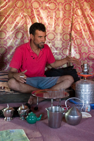
Mauritanian tea is served in three rounds, representing life, love, and death. Each serving is progressively sweeter, which is probably why I liked the "death" round the most. However, I normally do not drink a lot of caffeine, so I was quite jittery by the end of the third serving.
Here is a picture of Moktar Bujari Heiba, preparing the tea in his cousin's home:
Arkeiss is a very small village, with only ten or fifteen homes. There are no paved roads or street lights, and of course, no dock. So we were anchored about a mile offshore and needed to take the dinghy each time we disembarked.
Here is a picture from shore, with the dinghy en route to Errance in the distance (you can just make out the dinghy with two passengers aboard in the upper left):
Cap Tafarit is roughly 30 km north of the park, but it was as close as we were allowed to sail: visitors can only enter the park with an authorized guide. Our first day in Arkeiss, we made arrangements with a local fisherman to ride with him to Iwik, where we could find another guide to take us into the park. The fisherman was the only person in the village with a car, so he was our only option. He told us to be on shore waiting for him at 7 AM.
The next morning, we got up at 5:30 AM and piled into the dinghy. It was a new moon and since there were no lights on shore to guide us, we had to use the stars (Cassiopeia) to lead us there. The water was pretty rough, and we all got soaked -- each time a wave hit us, Anne or Annie would shriek and our grimaces momentarily turned into laughs. It took us about thirty minutes to get to shore and another ten minutes to carry the dinghy a half-mile to make sure it wouldn't drift away. Then we waited for our ride to show up.
At 7:45, we were still there, groggy and wet, and we found out from Bujari that the fisherman had waited for us and left. Frustration and confusion all around, but not much we could do. We wandered around the village another day, and we decided that we would sleep on land that night, so as not to miss our ride again the next morning.
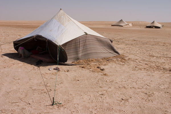
We stayed in a tent by the ocean, which sounds pretty cool, except that there were twenty-knot winds all night long and we couldn't close the tent flaps without the tent falling over. So we left them open and endured the sand that blew over us throughout the night.
Here's a picture of a tent similar to the one we stayed in:
A pickup truck arrived at 4:30 AM to pick us up, which explained why we'd missed the ride the previous day. We sat in the back of the pickup for half an hour, as the fisherman drove through the cold, pitch-black night at 50 mph along unmarked roads. Since I was sitting in the middle, I couldn't even grip anything to give me the false assurance that it would stop me from flying out when we hit the next bump. No one made a sound -- I think we were all silently making our peace with the world.
But all's well that ends well. And one of the things that kept me going was the thought that, if I survive, at least it will make a good blog entry :)
16º15.644' W
We sailed to Cap Tafarit in order to visit the Banc d'Arguin National Park. Since Mauritania's entire coastal region is less than 5 m deep, we needed a guide, Bujari, to navigate us safely through those waters. Near the cape is a village called Arkeiss. It turns out that one of Bujari's cousins lives there, and we were welcomed into his home for tea and lunch.
Mauritanian tea is served in three rounds, representing life, love, and death. Each serving is progressively sweeter, which is probably why I liked the "death" round the most. However, I normally do not drink a lot of caffeine, so I was quite jittery by the end of the third serving.
Here is a picture of Moktar Bujari Heiba, preparing the tea in his cousin's home:
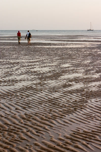
Arkeiss is a very small village, with only ten or fifteen homes. There are no paved roads or street lights, and of course, no dock. So we were anchored about a mile offshore and needed to take the dinghy each time we disembarked.
Here is a picture from shore, with the dinghy en route to Errance in the distance (you can just make out the dinghy with two passengers aboard in the upper left):
Cap Tafarit is roughly 30 km north of the park, but it was as close as we were allowed to sail: visitors can only enter the park with an authorized guide. Our first day in Arkeiss, we made arrangements with a local fisherman to ride with him to Iwik, where we could find another guide to take us into the park. The fisherman was the only person in the village with a car, so he was our only option. He told us to be on shore waiting for him at 7 AM.
The next morning, we got up at 5:30 AM and piled into the dinghy. It was a new moon and since there were no lights on shore to guide us, we had to use the stars (Cassiopeia) to lead us there. The water was pretty rough, and we all got soaked -- each time a wave hit us, Anne or Annie would shriek and our grimaces momentarily turned into laughs. It took us about thirty minutes to get to shore and another ten minutes to carry the dinghy a half-mile to make sure it wouldn't drift away. Then we waited for our ride to show up.
At 7:45, we were still there, groggy and wet, and we found out from Bujari that the fisherman had waited for us and left. Frustration and confusion all around, but not much we could do. We wandered around the village another day, and we decided that we would sleep on land that night, so as not to miss our ride again the next morning.
We stayed in a tent by the ocean, which sounds pretty cool, except that there were twenty-knot winds all night long and we couldn't close the tent flaps without the tent falling over. So we left them open and endured the sand that blew over us throughout the night.
Here's a picture of a tent similar to the one we stayed in:
A pickup truck arrived at 4:30 AM to pick us up, which explained why we'd missed the ride the previous day. We sat in the back of the pickup for half an hour, as the fisherman drove through the cold, pitch-black night at 50 mph along unmarked roads. Since I was sitting in the middle, I couldn't even grip anything to give me the false assurance that it would stop me from flying out when we hit the next bump. No one made a sound -- I think we were all silently making our peace with the world.
But all's well that ends well. And one of the things that kept me going was the thought that, if I survive, at least it will make a good blog entry :)
posted by james at 10:00 AM
![]()

1 Comments:
Good blog entry, indeed. however, the picture of the two people walking...with the boat to the LEFT? or right. i can't see anything to the left. a little black dot near the center...maybe a little to the left next to a person's head? is that it? in any case, still not "upper left"! stay away from the navigation, james.
Post a Comment
<< Home